← Preserve TR · Explainer
Most decisions about whether your neighbor's farmland gets subdivided don't get made when the developer files an application. They were made years ago, in a map most residents have never seen. Here's how it works.
The City's Future Land Use Map has already pre-designated nearly every piece of agricultural and vacant land inside Travelers Rest for residential development. There is no "future agricultural" or "future vacant" category on the map. So when a project gets reviewed for being "consistent with the Comprehensive Plan," the answer is almost always yes — because the Plan already said yes, years before anyone applied.
01 / See for yourself
Below are two maps published by the City of Travelers Rest. The map on the left shows what's actually on the ground today — what the city looks like as you drive through it. The map on the right shows what the City's plan says it should become.
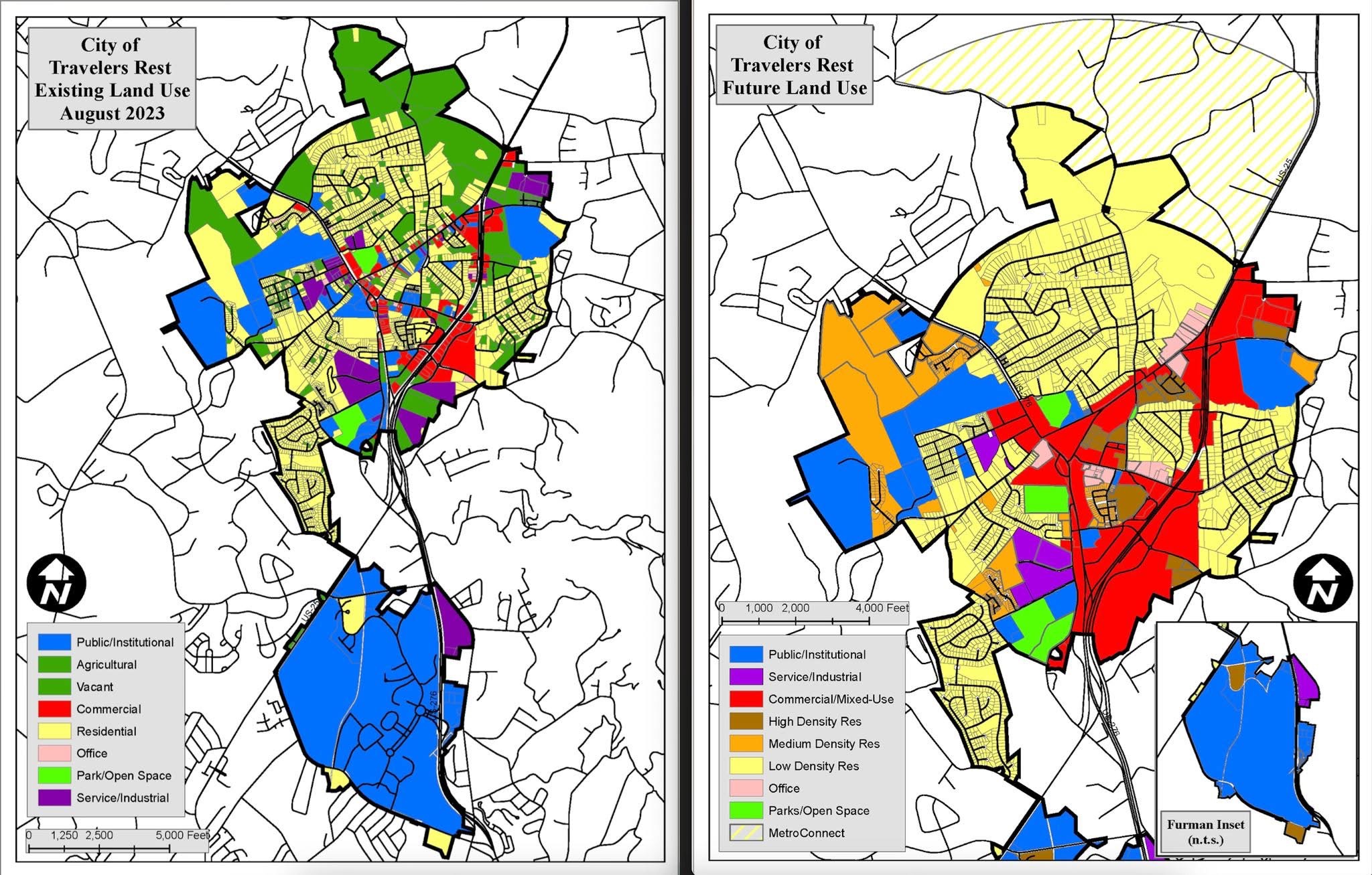
Look at the legends. The left map has these categories for undeveloped land:
Now look at the legend for the map on the right. Those two categories are gone. Instead, that land is painted:
"Agricultural" and "Vacant" are not on the future map. The plan has already converted them.
02 / The three maps that govern your neighborhood
Most residents assume that if a piece of land is being used as a farm or is sitting as woods, it's "agricultural" or "rural" and protected. It is not. The City uses three different categorizations for any given parcel, and they don't always agree:
Existing Land Use describes how the land is being used right now: farm, woods, vacant lot, house, store. It changes every time a project is built.
Zoning is the rule that says what can be built. R-15, for example, means single-family homes on 15,000 sq ft minimum lots. Zoning can be changed by City Council.
Future Land Use Map (FLUM) is the City's stated plan for what each parcel should eventually become. This is the document the Planning Commission uses to evaluate whether a new development is "consistent with the Comprehensive Plan."
Here's the trap: when residents see a wooded lot or a farm, they think category #1 protects it. It doesn't. The thing that determines whether that land gets developed is category #3 — the FLUM — and the FLUM almost always says yes.
03 / How this plays out at the meeting
When a developer applies for a rezoning, a subdivision approval, or an annexation, the Planning Commission and City Council are required to evaluate the request against the Comprehensive Plan. The key test is whether the proposal is consistent with the Future Land Use Map.
What you'll hear at a Planning Commission meeting
"Staff has reviewed the application and finds the proposed use is consistent with the City's Future Land Use Map, which designates this parcel as Low Density Residential. Staff recommends approval."
That sentence — some version of it — is what closes the door on most opposition. Once a project is found "consistent with the plan," the burden falls on residents to argue against the City's own planning document. That's a much harder fight than arguing against a developer.
And it's not just rural land at risk. The Comprehensive Plan also lays out areas designated for Medium Density and High Density Residential — usually adjacent to existing single-family neighborhoods. When apartments or townhomes get proposed in those spots, the same logic applies: the plan already said yes.
04 / What this is not
It's worth being precise about what the Future Land Use Map does and doesn't do, because the City is correct when it points out the following:
The FLUM is not zoning. A parcel designated "Low Density Residential" on the FLUM still needs to be rezoned (if necessary) before development can happen. The map is a guide, not an automatic permit.
The FLUM doesn't force any specific project. The City still has the discretion to deny a project if there are valid grounds — infrastructure capacity, traffic, environmental constraints, or annexation that doesn't serve the public interest.
Both of those things are true. But they shouldn't obscure the larger point: the FLUM creates a default of "yes" for residential development on nearly all of the City's remaining undeveloped land. Overcoming that default requires either a Comprehensive Plan amendment (rare) or a credible case for denial grounded in the specifics of that project (where most opposition has to fight).
05 / What residents can do about it
Sources
The next chance to redraw the Future Land Use Map is the Comprehensive Plan update due by 2028. Public input shapes that document. We'll let you know when meetings are scheduled.